Water situation snapshots
Select snapshot
Groundwater level
 Send your observations
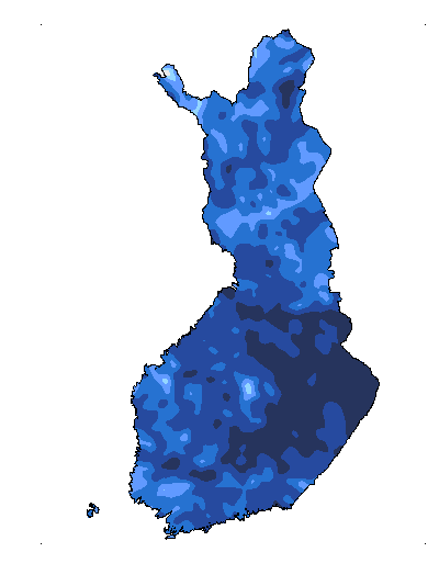
Groundwater level situation 16.6.2026
Groundwater levels still low in central and eastern parts of the country
The water levels of most small groundwater bodies are declining as is typical of summer. In places, rainwater has slowed down the decline in smaller bodies. In larger groundwater deposits, the water levels are also declining.
The water levels of small groundwater deposits in the south are normal or 15-40 cm lower than average. The water levels in Central Finland are mostly 15–70 cm lower than usual. In the north, the water levels are mainly average or 20–55 cm higher than average. The exception is the Kainuu region, where the water levels are mostly 30–40 cm and, in places, 110 cm below average.
The water levels of medium and large groundwater bodies in the southern parts of the country are lower than average. Some water levels in the west are 20–55 cm lower than normal and in the east 35–75 cm lower than normal. In the eastern parts of Central Finland, the water levels are mainly 20–70 cm lower than average. In the west, the water levels are 15–40 cm lower than usual. The water levels in the north are close to the averages. Some water levels are 50 cm lower than average.
After the groundwater reserves have been replenished by the melting snow in the spring, the water levels will start declining. The decline continues throughout the summer, as a result of increased evaporation in the growing season. Small groundwater deposits react faster and more strongly to changes in weather conditions than larger groundwater bodies, which is why summer rainfall may decelerate the summery decline of small deposits.
The groundwater situation provides an overview of groundwater levels
The groundwater situation is based on groundwater level measurements carried out at monitoring stations in different parts of Finland. The stations are established in areas that are as natural as possible. They represent different climatic and soil conditions. The monitoring network is sparse, and it is therefore important to note that the situation may vary greatly depending on local conditions. The best local groundwater information can be obtained from water utilities, water co-operatives and well users. The observations may also differ from the values calculated by the hydrological model shown on the map.
Local observers perform groundwater level measurements with observation tubes installed vertically in the ground twice a month. At several groundwater stations, the water level is also measured with automatic equipment. The measurement results are presented as altitudes above sea level in the N2000 height system and stored in the groundwater register (POVET).
The next groundwater situation will be published in week 27.
Further information
Groundwater data in open environmental information systems (Hertta service, available in Finnish)

Why is groundwater important?
After glaciers, groundwaters make up the second largest fresh water reserve on the Earth. Compared to our population, we have plenty of high-quality and accessible groundwater in Finland, and around 65% of domestic water supplied by water utilities in this country is groundwater.
What is actually groundwater?
Groundwater refers to all water under the ground surface that fills open spaces in the soil and bedrock fractures. Groundwater is formed when rainwater, water from snowmelt or surface water infiltrates into soil layers or flows into cracks in the bedrock. Impurities are removed from groundwater as it is filtered through soil layers, making it ideal as a source of drinking water. Some of our tap water comes from artificially recharged groundwater deposits, where surface water has been infiltrated into the soil. While the groundwater reserves in Finland recharge rapidly, there are great variations in the recharge rate globally.
Where can groundwater be found?
Groundwater occurs everywhere but particularly large volumes are formed in areas with sand and gravel deposits ideal for the infiltration of water. Areas with a rich supply of groundwater are called groundwater areas. Groundwater levels are affected by geographical location, soil types, seasons, weather conditions and human actions. The groundwater surface is usually found at a depth of two to five metres below the ground level, and considerably deeper at the centre of sand and gravel deposits. If you have a well, you can see the groundwater level by looking into it. A spring is an outlet where groundwater bubbles out of the ground.
Groundwater and the seasons
Groundwater levels fluctuate naturally as seasons come and go. As the lengths of the seasons vary in different parts of the country, so do fluctuations in groundwater levels. The volume of groundwater decreases in winter because precipitation mainly comes as snow and soil frost prevents the infiltration of water into the soil. Groundwaters are typically at their lowest level in late summer as plants use up water and it evaporates in large quantities throughout the summer, and there may also be long periods of drought. The largest quantities of new groundwater are formed during spring snowmelt and autumn rains.


